Below are 11 infographics that explain the Israeli-Palestinian Apartheid. The graphics provide facts about the forced exile of Palestinian people, how the occupation has been maintained, the ongoing displacement of families and destruction of homes, the pattern of violence, illegal detentions, segregation of necessary resources like water and olive trees, segregation on travel and the wall. Just as was done during South African Apartheid, there is a campaign to put economic pressure on Israel using boycotts, divestment and sanctions.
All the graphics are from the site Visualizing Palestine, a site dedicated to creating informative and impactful graphics about the troubled region. Check out many more of these images on their site.
1. The Forced Exile of The Palestinian People
DESCRIPTION
[May 2013] 15 May, 2013, marked the 65th anniversary of the Nakba – when 750,000 Palestinians were displaced from the territory that became Israel. In 1948, more than 50% of the entire Palestinian population was ethnically cleansed. In commemoration of the Nakba, and the displacement that continues today, VP released ‘An Ongoing Displacement’. The graphic references the iconic ‘Disappearing Palestine’ image, adding a layer of detail that quantitatively catalogues the multiple dimensions of Palestinian displacement and loss of land.
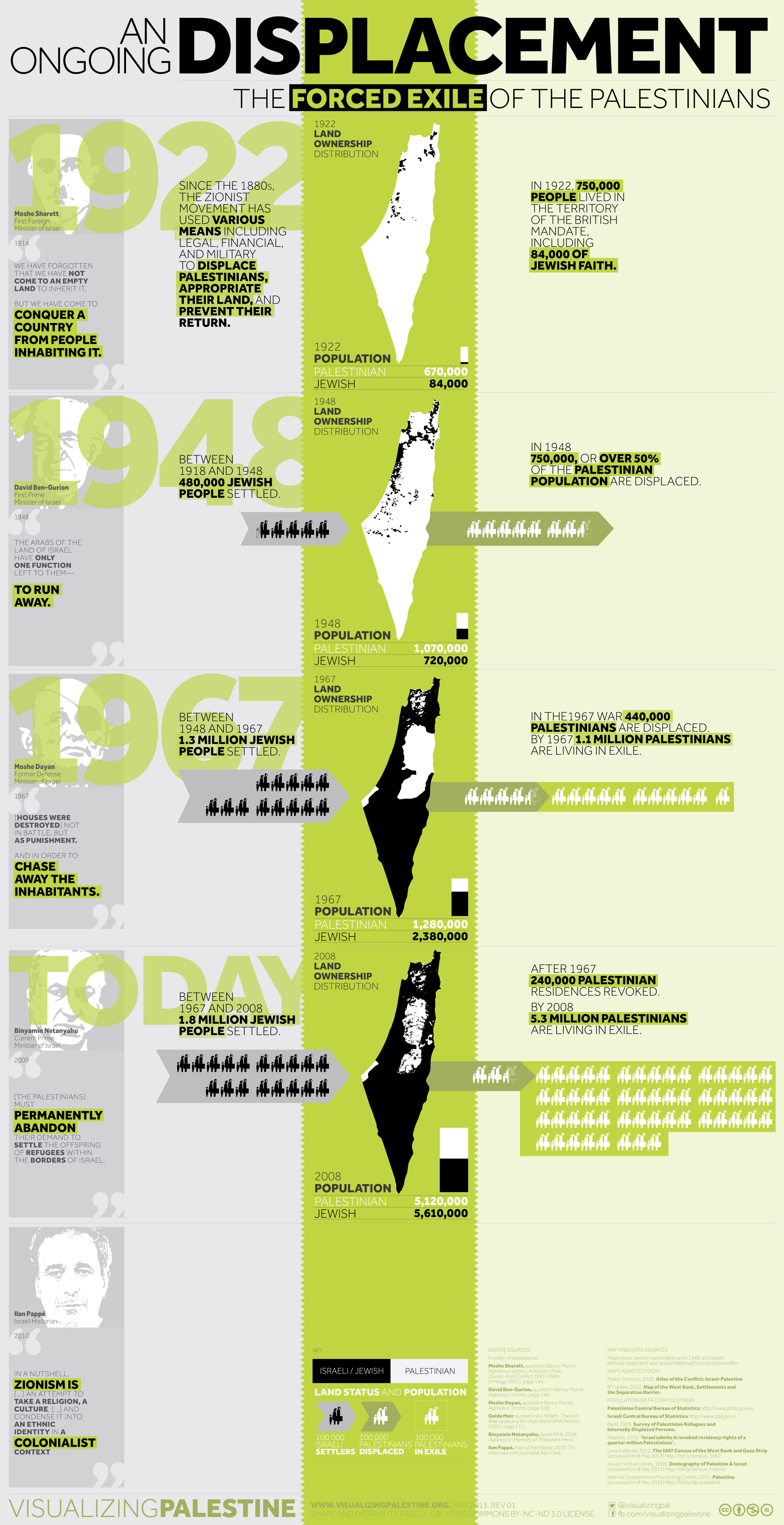
Quote Sources
Moshe Sharett, quoted in Benny Morris, Righteous Victims: A History of the Zionist-Arab Conflict 1881–1999 (Vintage 2001), pg. 144
David Ben-Gurion, ibid. pg. 144
Moshe Dayan, ibid. pg. 328
Golda Meir quoted in Avi Shlaim, The Iron Wall: Israel and the Arab World (WW Norton 2001), pg. 311
Binyamin Netanyahu, Israel MFA, 2009, ‘Address in Memory of Theodore Herzl.’ (accessed on 14 May 2013)
Ilan Pappe, Hart of the Matter, 2010. TV interview with journalist Alan Hart (accessed on 14 May 2013)
Maps Adapted from
Malkit Shoshan, Atlas of the Conflict: Israel-Palestine (010 Publishers 2010)
B’Tselem, 2012. Map of the West Bank, Settlements and the Separation Barrier (accessed on 14 May 2013)
Population Data Compiles from
Palestinian Central Bureau of Statistics, 2013 (accessed on 14 May 2013)
Israeli Central Bureau of Statistics, 2013 (accessed on 14 May 2013)
Badil, 2009. Survey of Palestinian Refugees and Internally Displaced Persons (PDF)
Haaretz, 2012. ‘Israel admits it revoked residency rights of a quarter million Palestinians’. (accessed on 8 May 2013)
Levy Institute, 2012. The 1967 Census of the West Bank and Gaza Strip (accessed on 8 May 2013)
Jewish Virtual Library, 2006. Demography of Palestine & Israel (accessed on 8 May 2013)
Internal Displacement Monitoring Centre, 2011. Palestine (accessed on 8 May 2013)
2. Maintenance of the Occupation
DESCRIPTION
[December 2013] Twenty years ago, the PLO Central Council approved the Oslo Accord with the Israeli government. Israeli-Palestinian talks were slated to conclude within 5 years, yet two decades on Israel’s occupation continues, and the situation on the ground has only moved backwards for Palestinians. This graphic, a collaboration between VP and AIDA (the Association for International Development Agencies), highlights the ever-increasing Israeli settler population, continuing dispossession of Palestinians, and comprehensive system of segregation that define the landscape. In spite of the Palestinian Authority’s ‘statehood’ project, the feasibility of a ‘two-state solution’ is now widely questioned, while Palestinian self-determination and the return of refugees are barely discussed.
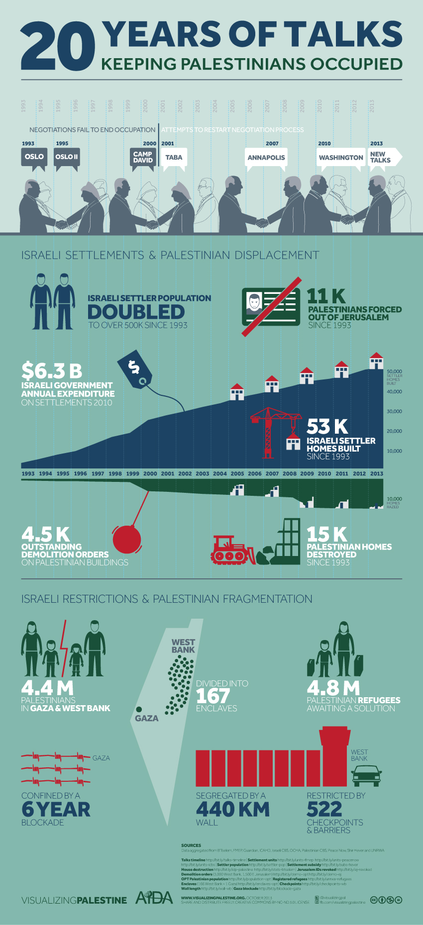
Talks Timeline. The Guardian, 2011. Timeline: Middle East Peace Talks (accessed on 3 December 2013)
Settlement Units. Foundation for Middle East Peace, 2012. Housing Stats in Israel, West Bank, and Gaza (2010-2011) (accessed on 3 December 2013) & Peace Now, 2011. The Settlements: The Biggest Threat to a Two-State Solution (PDF) & Israeli Central Bureau of Statistics, 2013. Table 4: Dwellings, by stage of construction, district and construction initiator (PDF)
Settler Population. B’Tselem, 2013. Statistics on Settlements and Settler Population (accessed on 3 December 2013)
Settlement Subsidy. Shir Hever in Newsweek, 2011. The Economics of Occupation (accessed on 3 December 2013)
House Destruction. Internal Displacement Monitoring Centre, 2011. The State of Palestine (accessed on 3 December 2013) & data aggregated from B’Tselem, 2013. Statistics on Destruction of Property (accessed on 3 December 2013)
Jerusalem IDs Revoked. B’Tselem, 2013. Statistics on Revocation of Residency in East Jerusalem (accessed on 3 December 2013)
Demolition Orders (3,000 West Bank). UN OCHA, 2011. Humanitarian Factsheet on Area C of the West Bank (PDF)
Demolition Orders (1,500 E Jerusalem). Israeli Committee Against House Demolitions, 2013. Israel’s Policy of Demolishing Palestinian Homes Must End: ICAHD Submission to the UN (accessed on 3 December 2013)
OPT Palestinian Population. Palestinian Central Bureau of Statistics, 2013. Population Statistics (accessed on 3 December 2013)
Registered Refugees. UNRWA, 2012. In Figures (PDF)
Enclaves (166 West Bank + 1 Gaza). B’Tselem, 2013. Acting the Landlord: Israel’s Policy in Area C, the West Bank (accessed on 3 December 2013)
Checkpoints. B’Tselem, 2013. Checkpoints, Physical Obstructions, and Forbidden Roads (accessed on 3 December 2013)
Wall Length. B’Tselem, 2012. The Seperation Barrier – Statistics (accessed on 3 December 2013)
Gaza Blockade. B’Tselem, 2013. The Siege on Gaza (accessed on 3 December 2013)
3. Continued Displacement and Destruction
DESCRIPTION
[September 2012] ‘Policy of Displacement’ focuses on the Israeli government’s widespread practice of demolishing Palestinian homes in the West Bank and Gaza since 1967. The data for the graphic draws primarily on research by the Israeli Committee Against House Demolitions (ICAHD). The graphic was first published by Al Jazeera English on 28 August, two days after the verdict on Rachel Corrie’s case. It served as a reminder of the outrage home demolitions spur, both within Palestinians and among the international community. This was our first release by a major media outlet.
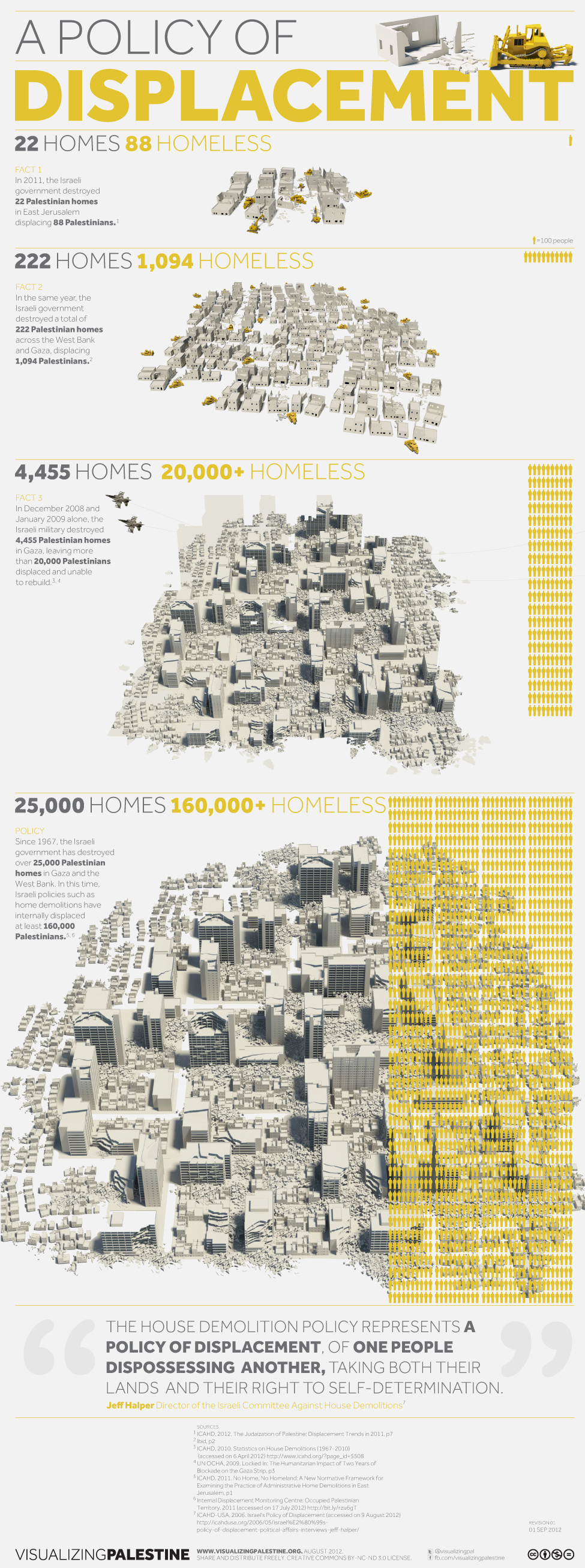
ICAHD, 2012. The Judaization of Palestine: Displacement Trends in 2011 (PDF)
ICAHD, 2010. Statistics on House Demolitions (1967-2010). (accessed on 6 April 2012)
UN OCHA, 2009. Locked In: The Humanitarian Impact of Two Years of Blockade on the Gaza Strip (PDF)
ICAHD, 2011. No Home, No Homeland: A New Normative Framework for Examining the Practice of Administrative Home Demolitions in East Jerusalem (PDF)
Internal Displacement Monitoring Centre, 2011.The state of Palestine (accessed on 17 July 2012)
ICAHD-USA, 2006. Israel’s Policy of Displacement. (accessed on 9 August 2012)
4. A Pattern of Violence and Aggression
DESCRIPTION
[November 2012] ‘Timeline of Violence’ reflects on the death toll and cycles of killing in the Israeli-Palestinian issue, drawing on detailed data gathered by B’Tselem since the outbreak of the Second Intifada in September 2000. The graphic was released in November 2012 by Al Jazeera, amidst Operation Pillar of Cloud, the Israeli bombardment of Gaza. News coverage consistently described the bombardment as defensive, a response to a protracted barrage of Hamas rockets. The graphic called this coverage into question by displaying the stark disparity between Palestinians and Israelis killed since 2000.
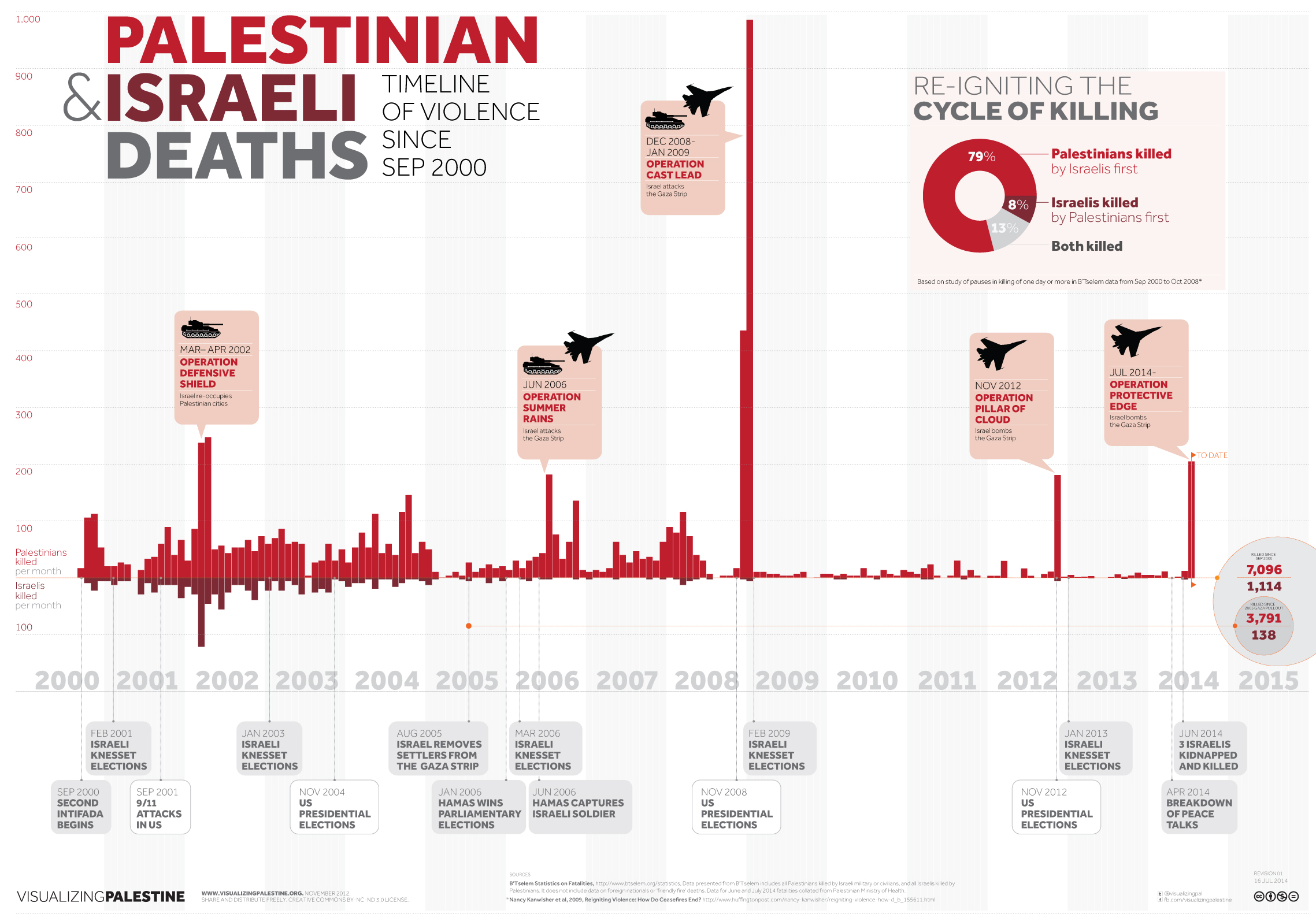
B’Tselem, 2012. Statistics (accessed on November 2012)
Huffington Post, 2009. Reigniting Violence: How Do Ceasefires End? (accessed on November 2012)
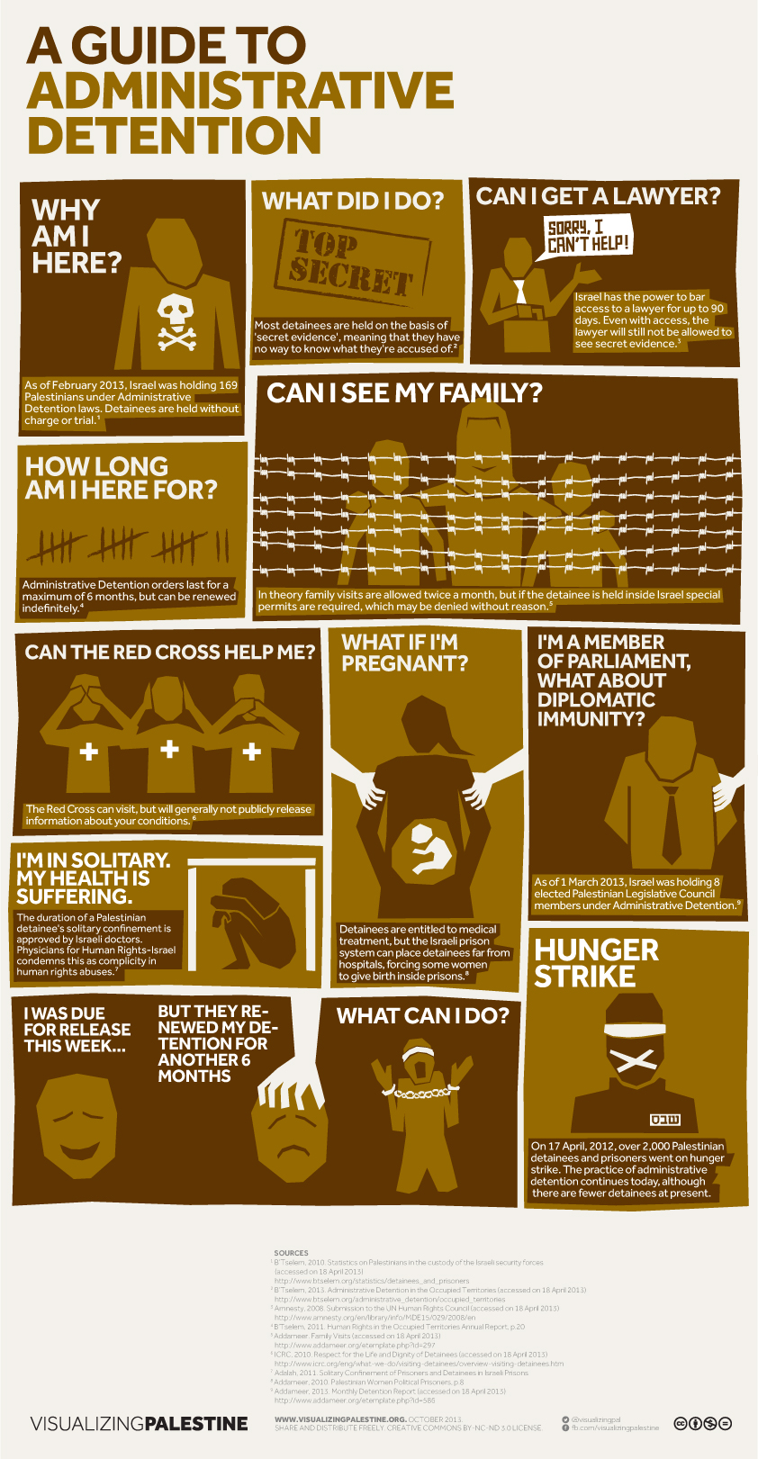
5. Illegal Detention
DESCRIPTION
[October 2013] In May 2012, over 2,000 Palestinian prisoners and detainees went on hunger strike to challenge the conditions they face in the Israeli prison system. Not least, they called for an end to the practice of administrative detention, where Palestinians are held without charge or trial for months or even years. Despite drawing worldwide attention to the issue, administrative detention continues today. The infographic ‘A Guide to Administrative Detention’ takes the perspective of an administrative detainee as they face daily stresses, uncertainties and indignities.
B’Tselem, 2010. Statistics on Palestinians in the custody of the Israeli security forces (accessed on 18 April 2013)
B’Tselem, 2013. Administrative Detention in the Occupied Territories (accessed on 18 April 2013)
Amnesty, 2008. Submission to the UN Human Rights Council (accessed on 18 April 2013)
B’Tselem, 2011. Human Rights in the Occupied Territories Annual Report, p.20 (PDF)
Addameer. Family Visits (accessed on 18 April 2013)
ICRC, 2010. Respect for the Life and Dignity of Detainees (accessed on 18 April 2013)
Adalah, 2011. Solitary Confinement of Prisoners and Detainees in Israeli Prisons (PDF)
Addameer, 2010. Palestinian Women Political Prisoners, p.8 (PDF)
Addameer, 2013. Monthly Detention Report (accessed on 18 April 2013)
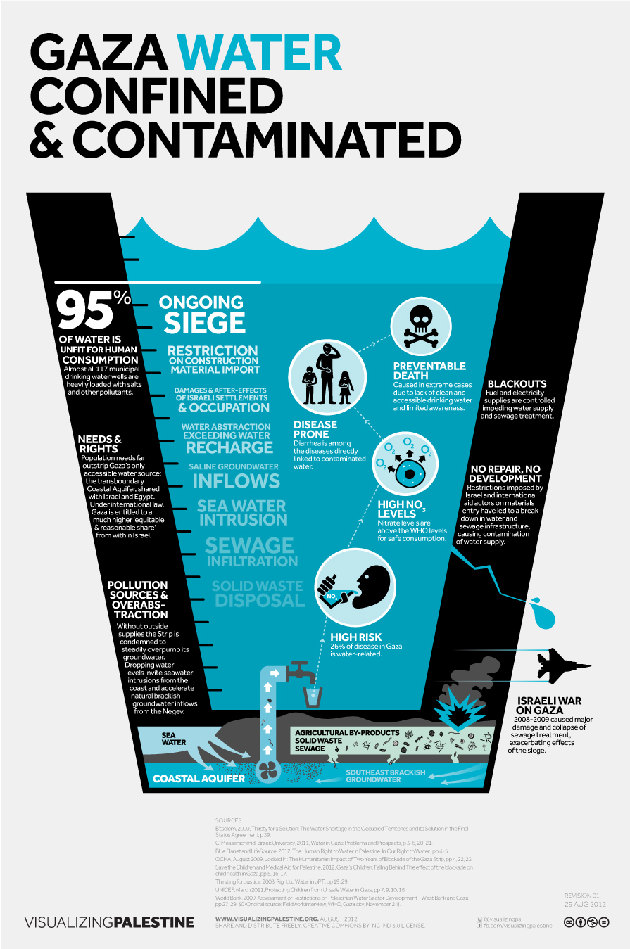
6. Segregation of Resources – Gaza Water: Confined & Contaminated
DESCRIPTION
[September 2012] ‘Gaza Water’ gives insight on the dire water situation in the Gaza Strip. As much as 95% of Gaza’s water from its only accessible water source–the Coastal Aquifer–is now contaminated and unfit for human consumption. Overpopulation leads to over-pumping, and the Israeli government draws an inequitable amount of water from the aquifer, both of which accelerate contamination. This leads to alarmingly high levels of water-related illness among Gazans.
B’tselem, 2000. Thirsty for a Solution: The Water Shortage in the Occupied Territories and its Solution in the Final Status Agreement (accessed on August 2012)
Ibrahim Abu Lughod Institute of International Studies, 2011. Water in Gaza: Problems and Prospects (PDF)
Blue Planet Project, 2012. The Human Right to Water in Palestine, In Our Right to Water (PDF)
UN OCHA, 2009. Locked In: The Humanitarian Impact of Two Years of Blockade on the Gaza Strip (PDF)
Save the Children, 2012. Gaza’s Children: Falling Behind The effect of the blockade on child health in Gaza (PDF)
Center for Economic and Social Rights, 2003. Thirsting for Justice (PDF)
UNICEF,2011. Protecting Children from Unsafe Water in Gaza (PDF)
World Bank, 2009. Assessment of Restrictions on Palestinian Water Sector Development (PDF)
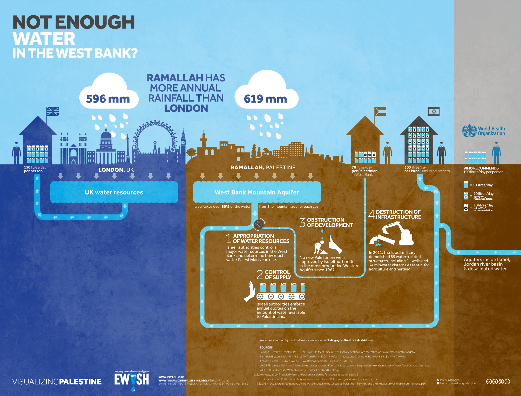
7. Segregation of Resources – West Bank Water
DESCRIPTION
[March 2013] In partnership with EWASH (a coalition working in the water and sanitation sector in Palestine), VP produced ‘West Bank Water’, which describes the ways in which the Palestinian water supply in the West Bank is appropriated by the Israeli government before it reaches Palestinian homes. Despite the fact that Ramallah receives more rainfall than London (one of the world’s most renowned rainy cities), the average West Bank Palestinian can access only one quarter of the water available to the average Israeli each day, and 30 liters less than the World Health Organization’s minimum recommendation.
UK Met Office, 2012. Historic Station Data (accessed on 21 March 2012)
Palestinian Water Authority, 2003. Rainfall Variability and Change in the West Bank (PDF)
“Amnesty, 2009. Troubled Waters – Palestinians denied fair access to water” (PDF)
UK DEFRA, 2013. Domestic Water Saving (accessed on 7 February 2013)
WHO, 2003. Domestic Water Quantity, Service Level and Health (PDF)
C. Messerschmid, 2007. Hydro-hegemony in shared Israeli, Palestinian groundwater resources (PDF)
EWASH, 2012. Israeli restrictions on the WASH sector in the Occupied Palestinian Territory and their impact on vulnerable communities (PDF)
8. Segregation of Resources – Uprooted: Olive Harvest
DESCRIPTION
[October 2013] October marks the start of the annual Palestinian olive harvest, an ancient tradition on which 80,000 families still rely for their livelihoods. Yet these families face growing economic hardship due to Israeli land confiscations, access restrictions, settler attacks, and not least the widespread uprooting, destruction and theft of the trees themselves. The infographic ‘Uprooted’ focuses on the staggering fact that Israeli authorities have uprooted over 800,000 Palestinian olive trees since 1967, the equivalent to razing all of the 24,000 trees in New York’s central park 33 times.

800,000 olive trees uprooted. Oxfam, 2011. Olive Harvest Factsheet, p2 (PDF)
24,000 trees in Central Park. Central Park, 2013. Official Website, Frequently Asked Questions (accessed 31 May 2013)
$12.3million loss = 10% of potential peak year income from the 8 million remaining trees in West Bank and Gaza. UN OCHA, 2012. Olive Harvest Factsheet & UNDP, 2008. The Olive Harvest in the West Bank & Gaza Strip (PDFs)
80,000 families rely economically on olive harvest. UN OCHA, 2012. Olive Harvest Factsheet (PDF)
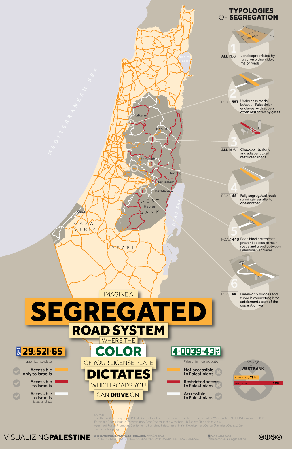
9. Segregation of Travel – Segregated Roads
DESCRIPTION
[May 2012] Cars with Palestinian license plates are not allowed on Israeli roads, regardless of the identification held by the driver. Even on Palestinian roads, cars with Palestinian plates have restricted access, face endless delays at checkpoints and are subject to regular road blocks. Cars with Israeli plates experience none of these difficulties. The infographic ‘Segregated Roads’ invites the viewer to imagine a road system in which the color of your license plate determines your mobility.
UN OCHA, 2007. The Humanitarian Impact on Palestinians of Israeli Settlements and other Infrastructure in the West Bank (PDF)
B’Tselem, 2004. Forbidden Roads: Israel’s Discriminatory Road Regime in the West Bank (PDF)
Ma’an Development Center, 2008. Apartheid Roads: Promoting Settlements, Punishing Palestinians (PDF)
Open Street Map, 2012 (accessed on May 2012)
10. Segregation of Travel – Bus Segregation
DESCRIPTION
[March 2013] Bus segregation addressed the Israeli Transportation Ministry’s decision to open two bus lines accessible only to West Bank Palestinians. The Israeli government’s stated reasons were “to help make life easier for Palestinians permitted to work in Israel” and to assuage Israeli “passengers on the buses complain[ing] about unpleasant experiences, nuisances and fear”. Behind the pretense ease and comfort are countless instances of Palestinians being beaten and forced off buses by Israeli passengers, just as black Americans reported in the 1950s and 1960s.
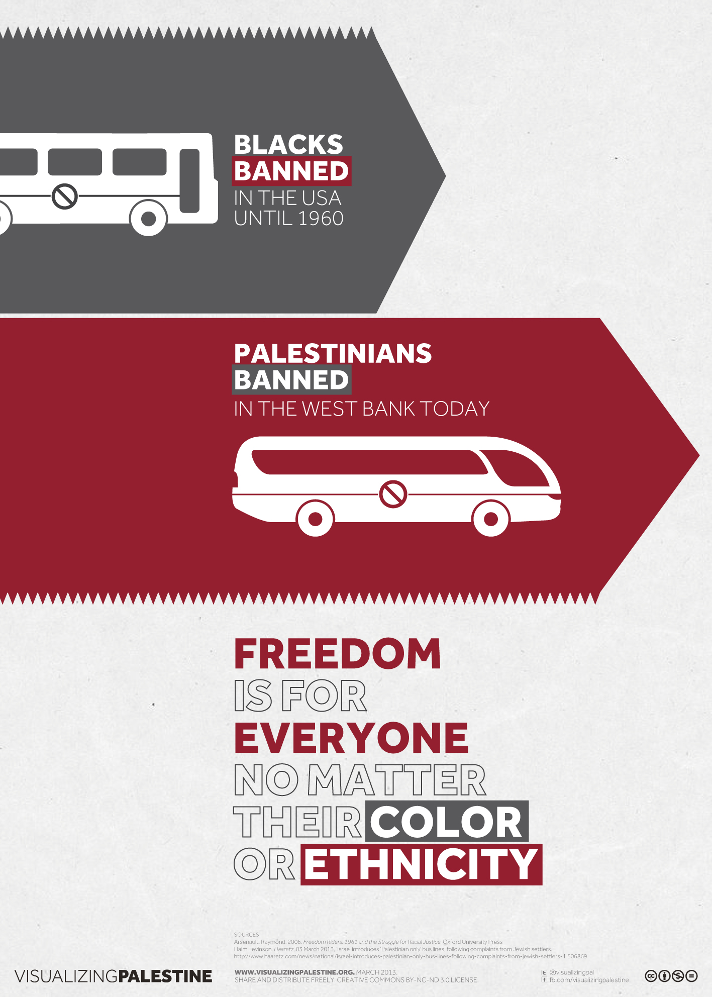
Arsenault, Raymond, 2006. Freedom Riders: 1961 and the Struggle for Racial Justice. Oxford University Press.
Haaretz, 2013. Israel introduces ‘Palestinian only’ bus lines, following complaints from Jewish settlers (accessed on 4 March 2012)
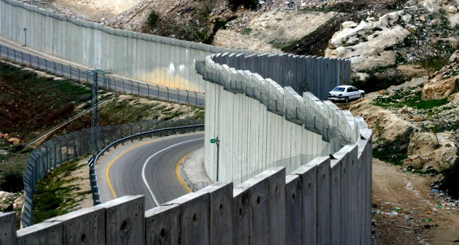
11. The Wall
DESCRIPTION
[July 2014] In June 2002, the Israeli cabinet approved the construction of a “continuous fence” in the West Bank. In July 2004, the International Court of Justice (ICJ) declared this barrier illegal, choosing to refer to it as a “wall”. The infographic ‘Where Law Stands on the Wall’ describes the detail of ICJ’s decision. Today, 9 years on, and despite wide condemnation, little has been done by the international community to hold the Israeli government accountable for its ongoing disregard of international law.